FlightTrack allows you to display your flights on
top of a 3D rendered terrain. In order to do this, you have to get some
DEM (Digital Elevation Model) files of the area where you fly. You can
have several set of DEM files and FlightTrack will automatically choose
the one that contains the track you want to view. If you don't have a
DEM file for a track, it will be displayed over a green grid
representing the ground.
A DEM set is made of at least two files: the header and the data file.
The header is a small text file (.hdr extension) that contains layout
information. The data file is a binary file containing the actual
elevation data. It has a .bin or .dem extension.
You can freely get these
files
for any place on earth from
the
GLOBE project or the GTOPO project. I recommend using the GLOBE project
since you have the ability to download any area of your choice.
5 easy steps
Jump to the GLOBE project page (it will open in a new window).
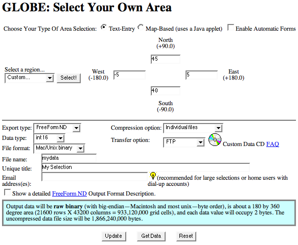
You will be presented with a form where you should enter the
coordinates
of the box around the area you wish to download.
You only have to enter the 4 coordinates. You can also change the
file name and unique title.
Make sure the value entered in the North box is greater than
the one in the South box.
Make sure the value entered in the East box is greater
than the one in the West box.
Click on the 'Get Data'
button. The page will be refreshed until your selection is ready. A
10° by 10° selection occupies about 3 MB and will be ready in
about 3 minutes.
Once the data is ready the page will present you with 3 links,
you should download both the .hdr file
(text header) and the .bin
(actual
data) in the same folder on you hard drive. You should not change
the name of the files! Be careful, sometimes, browsers
automatically add a .txt suffix
to the header file.
These files should finally be moved to the Application Support/FlightTrack/DEMs
folder of the Library folder
in your home directory. On non-english versions of MacOS X, the Library
folder will have a different name but it will always have the same icon:
You can check that it is properly installed by opening the DEM info
panel (Options -> Show DEMs...
menu). The panel should display the list with all available DEMs, and a
preview picture.
Note: since the data
file
ends in .bin,
you mac might think that it is a MacBinary file, it isn't, you
don't have to decompress it.